

Viamapa with its experience in the of road infrastructuresViamapa has developed the best solutions in terrestrial LASER - MLS (Mobile Laser Scanning) in Portugal, France, Spain, Africa (Mozambique, Zambia, Cape Verde...) and, more recently, in Airborne LiDAR (Light Detection and Ranging) MMS (Mobile Mapping) e ALS (Airborne Laser Scanning).

We are pioneers insurveys using Mobile Laser Scanner
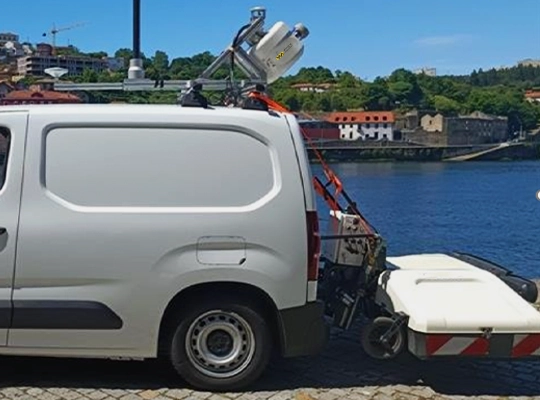
The Mobile Mapping consists in the execution of high precision surveys using land mobile LiDAR technology that can be exponentiated with aerophotogrammetric data obtained by the same system and by Drones for the collection of georeferenced images allowing for a realistic and exhaustive view of the track.
What is the Mobile Laser Scanner technology?
The technology of high frequencylaser scanning, ensures detailed mapping of large areas, giving rise to 3D point cloud (registering the GNS / DMI / IMU position and orientation) and high resolution image registrationusing 360º cameras.
What are its applications?
The applications of the data acquisition is made in any type of area, in a fast, automated way with high precision. Through these surveys, various elements of the public road and its surroundings will be georeferenced and collected, such as:
- Sidewalks, separators, kerbs, and curbs;
- Road signs (vertical and horizontal);
- Various networks;
- Urban furniture:
- Network of ecopoints;
- Public transportation stops;
- Tree boilers;
- Garden benches;
- Among others
- Constructions;
- Works of Art.
Mobile Laser Scanning at Airports
Our specialists, have conducted surveys, complementing Mobile Laser Scanner with Airborne LiDAR, of the runway and airportinfrastructures as well as the surrounding area, obtaining the necessary information for a comprehensive characterization of the airport core and the areas containing possible obstacles to air navigation.
These works were developed in the seven national and international airports of the Archipelago of Cape Verde.
What are the MLS Solutions / Technologies LIDAR ?
The Solutions / MLS LiDAR Technologies used and presented to the customer are:
- MLS - Mobile Laser Scanner (Track Zone)
- Airborne LiDAR (Area around the airport)
Advantages of the applied solutions / technologies ?
- Fast execution of the work
- Accuracy topography
- Little human intervention, therefore less likelihood of error
- Shorter occupation time of risk areas
- Less runway shutdown time, therefore less time interfering with the airport's daily operation plans
- High-density homogeneous point clouds, thus more information on the condition of the roadway sidewalk and contiguous drainage areas .

What are the Mobile Mapping Solutions (MMS)?
- Production / Editing / Updating of Topography and Cartography
- 3D models / as built
- BIM (Building Information Modeling)
- Vectorization and 2D / 3D modeling
- Smart Cities
- HD Maps for autonomous navigation
What does MMS mean?
Mobile mapping systems or MMS as well as the terrestrial laser scanner are some of our most advanced equipment, in collecting detailed data with millimeter precision that, through scanning techniques, form point clouds.
MMS can be docked in a car, train or ship
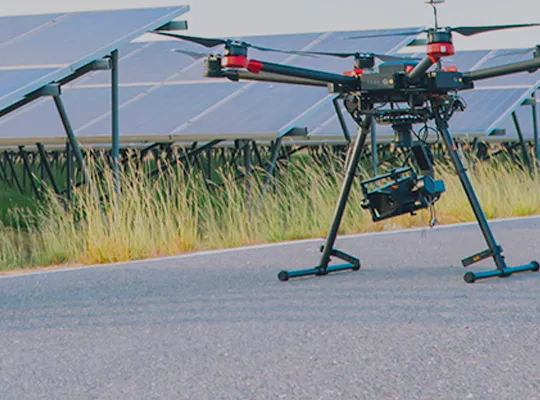
Aerial surveys using Photogrammetry and LiDAR
In addition to cartography using Mobile Mapping, we carry out cartography with drone using aerophotogrammetrythrough vertical and oblique aerial photography.
What are the applications of Drone Cartography?
Through Cartography with Drone for the realization of roads, railroads, bathymetry, mines, tunnels, , the solutions are :
- Topographic Cartography
- Cadastral Cartography
- Thematic Cartography
- Orthophoto maps
- Inspection of high voltage lines
- Digital models
Do you have any questions or would you like to have a talk about your project?
Click here or contact us through the contact form
Discover our cartography and aerial photography services
Mobile Mapping (MMS)
Mobile LiDAR mapping, Mobile mapping (MMS), 3D point cloud, laser scanning, HD Maps...
Drone
Aerial surveys, photogrammetry, LiDAR, drones, models, Topographic / Cadastral / Thematic cartography...